

 |  |  |  |
|---|---|---|---|
 |  |  |  |
 |  |  |  |

Limpopo

"Northern Transvaal" redirects here. For the rugby union team, see Blue Bulls. For the cricket team previously called Northern Transvaal, see Northerns (cricket team).
Limpopo (/lɪmˈpoʊpoʊ/) is the northernmost province of South Africa. It is named after the Limpopo River, which forms the province's western and northern borders. The capital and largest city in the province is Polokwane, while the provincial legislature is situated in Lebowakgomo.
The province is made up of three former homelands of Lebowa, Gazankulu and Venda and part of the former Transvaal province. The Limpopo province was established as one of nine provinces after the 1994 South African general election. The province's name was first "Northern Transvaal", later changed to "Northern Province" on 28 June 1995, with two other provinces. The name was later changed again in 2002 to the Limpopo Province. Limpopo is made up of three main ethnic groups: the Pedi, the Tsonga and the Venda.
Traditional leaders and chiefs still form a strong backbone of the province's political landscape. Established in terms of the Limpopo House of Traditional Leaders Act, Act 5 of 2005, the Limpopo House of Traditional Leaders' main function is to advise the government and the legislature on matters related to custom, tradition, and culture, including developmental initiatives that affect rural communities. On 18 August 2017, Kgosi Malesela Dikgale was re-elected as the Chairperson of the Limpopo House of Traditional Leaders.

 |  |  |  |
|---|---|---|---|
 |  |  |  |
 |  |  |  |
Geography
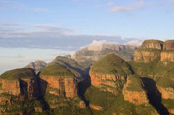
Sundown over one of the mountain ranges found in Limpopo.
Limpopo Province shares international borders with districts and provinces of three countries: Botswana's Central and Kgatleng districts to the west and northwest respectively, Zimbabwe's Matabeleland South and Masvingo provinces to the north and northeast respectively, and Mozambique's Gaza Province to the east. Limpopo is the link between South Africa and countries further afield in sub-Saharan Africa. On its southern edge, from east to west, it shares borders with the South African provinces of Mpumalanga, Gauteng, and North West. Its border with Gauteng includes that province's Johannesburg-Pretoria axis, the most industrialised metropolis on the continent. The province is central to regional, national, and international developing markets.
Limpopo contains much of the Waterberg Biosphere, a massif of approximately 15,000 km2 (5,800 sq mi) which is the first region in the northern part of South Africa to be named a UNESCO Biosphere Reserve.
Law and government
Main article: Politics of Limpopo
The current Premier of Limpopo Province is Stanley Mathabatha, representing the African National Congress.
Municipalities
Main article: List of municipalities in Limpopo
Limpopo districts and local municipalities
Limpopo Province is divided into five district municipalities. The district municipalities are in turn divided into 25 local municipalities:
District municipalities
Economy
Man and his donkeys collecting wood in a rural area
Limpopo has a total population of 6.015 Million with 1.641million Households., The province has a high Human Development Index (HDI) of 0.710, which is the third highest in South Africa.
Agriculture
The bushveld is beef cattle country, where extensive ranching operations are often supplemented by controlled hunting. About 80% of South Africa's game hunting industry is in Limpopo.
Sunflowers, cotton, maize and peanuts are cultivated in the Bela-Bela and Modimolle areas. Modimolle is also known for its table grapes. An embryotic wine industry is growing in Limpopo. Tropical fruit, such as bananas, litchis, pineapples, mangoes and pawpaws, as well as a variety of nuts, are grown in the Tzaneen and Louis Trichardt areas. Tzaneen is also at the centre of extensive citrus, tea, and coffee plantations and a major forestry industry. Most of the farmers and households lack a water supply. Therefore, they drill their boreholes on their premises.
Housing
Most Limpopo residents live in rural areas; this has led to a new phenomenon of rural development, where the residents have invested in building lavish homes on their tribal land. Limpopo rural houses have been profiled by TV channels, lifestyle vloggers, social media influencers, and Africa's biggest facts brand, Africa Facts Zone. According to 96.2% of Limpopo live in formal housing, above the national average of 84.0%. This makes Limpopo the province with the highest percentage of people living in formal housing in South Africa.
Mining
Ajoite in quartz, from the Messina mine, Limpopo Province, South Africa. Scale at bottom is one inch, with a rule at one cm.
Limpopo's rich mineral deposits include the platinum group metals, iron ore, chromium, high- and middle-grade coking coal, diamonds, antimony, phosphate, and copper, as well as mineral reserves like gold, emeralds, scheelite, magnetite, vermiculite, silicon, and mica. Commodities such as black granite, corundum, and feldspar are also found. Mining contributes to over a fifth of the provincial economy.
Limpopo has the largest platinum deposit in South Africa. The Waterberg Coalfield, the eastern extension of Botswana's Mmamabula coalfields, is estimated to contain 40% of South Africa's coal reserves.
Tourism
The Limpopo Department of Economic Development, Environment and Tourism has targeted the province as a preferred eco-tourism destination. Its Environment and Tourism Programme encompasses tourism, protected areas, and community environment development to achieve sustainable economic growth.
While Limpopo is one of South Africa's poorest provinces, it is rich in wildlife, which gives it an advantage in attracting tourists. Both the private and public sectors are investing in tourism development.
Near Modjadjiskloof, at Sunland Baobab farms, there is a large Baobab tree which has been fashioned into a relatively spacious pub.
Transportation and communications
The province has excellent road, rail, and air links. The N1 route from Johannesburg, which extends the length of the province, is the busiest overland route in Africa in terms of cross-border trade in raw materials and beneficiated goods. The port of Durban, South Africa's busiest, is served directly by the province, as are the ports of Richards Bay and Maputo. Polokwane International Airport is situated just north of Polokwane. Limpopo province contains approximately 56 airports and airstrips.
Education
The Department of Education is responsible for effecting quality education and training for all. The Department has to coordinate all professional development and support. Policies, systems, and procedures had to be developed.
Educational institutions
As of December 2020, 12.9% of the Limpopo population had attained some post-school qualifications. The following higher education institutions are found in Limpopo:
-
Tshwane University of Technology (Polokwane Campus)
-
Capricorn College for TVET (Seshego)
-
Capricorn College for TVET (Polokwane)
-
Lephalale TVET College (Lephalale)[
-
Letaba TVET College (Tzaneen)[
-
Mopani South East TVET College (Phalaborwa)
-
Sekhukhune TVET College (Motetema)
-
Vhembe TVET College (Venda)
-
Waterberg TVET College (Mokopane)
-
Giyani Campus Of Nursing College
-
Limpopo Province College of Nursing (Giyani Campus)

 |  |  |  |
|---|---|---|---|
 |  |
 |  |  |  |
|---|---|---|---|
 |  |

Sports
-
Association football: Polokwane was one of South Africa's host cities for the 2010 FIFA World Cup, with matches being played at the Peter Mokaba Stadium. Football clubs in the province include Real Rovers, Silver Stars, Black Leopards, Polokwane City, Baroka, Ria Stars, and Dynamos.
-
Rugby union: Limpopo has no provincial rugby team of its own; it is represented in the domestic Currie Cup by the Pretoria-based Blue Bulls. The Blue Bulls also operate a Super Rugby franchise, known simply as the Bulls. Limpopo nonetheless produces its share of top players. Most notably, the two most-capped forwards in the history of the country's national team, John Smit and Victor Matfield, are both natives of Polokwane.
-
Basketball: The province is home to Limpopo Pride, a professional team that plays in South Africa's top basketball division, the Basketball National League.
Demographics
The population of Limpopo consists of several ethnic groups distinguished by culture, language, and race. 97.3% of the population is Black, 2.4% is White, 0.2% is Coloured, and 0.1% is Indian/Asian. The province has the smallest percentage and second smallest total number of White South Africans in the country. However, there are several localities with a White majority, notably Hoedspruit and Modimolle. It also has the highest Black percentage out of all the provinces.
The Northern Sotho people comprise the largest percentage of the population, 52% of the province. The Tsonga people comprise about 24.0% of the province; the Tsonga also comprise about 11.5% of Mpumalanga province since the southern part of their homeland, Gazankulu, was cut off from Limpopo and allocated to Mpumalanga. The Venda make up about 16.7%. Afrikaners make up the majority of Limpopo's White population, about 95,000 people; English-speaking Whites number just over 20,000. Vhembe district has the smallest share of White people in Limpopo, about 5,000 total. In contrast, the Waterberg district has the largest share of Whites, with more than 60,000 Whites residing there. Coloureds and Asians/Indians make up a tiny percentage of the province's total population.
HIV / AIDS
At 18.5% (2007), Limpopo has a relatively high incidence of HIV compared to other South African provinces. Cases rose from 14.5% to 21.5% between 2001 and 2005, with a slight fall between 2005 and 2007. However, as at 2019, the Limpopo province HIV stats sat at (13.2%) which is one of the lowest in comparison with other provinces in South Africa.

| | | |
|---|---|---|---|
| |
